Download outputs of the SERDP models and OBIS-SEAMAP data
General
Among the SERDP data, only the outputs of the NODES Density Models are downlodable through the online download wizard. For other model outputs, please contact us.
For the OBIS-SEAMAP data, the observation records and effort / telemetry tracks that are currently on the map can be downloaded as a CSV or an ESRI shapefile. Data follow the standardized OBIS-SEAMAP schema and not from the data originally provided by data providers. They include publicly available fields: locations, date/time of the observations and the species identification. See below for more details about the fields.
Also see "FAQ" at the bottom of the page.
How to download NODES Density Model outputs
- Select "Outputs of SERDP NODES Density Models".
- Make sure "As shapefile" is selected (other formats are not selectable).
- Click [Start Download] button.
Notes
- The model outputs are available in ESRI shapefile format only. The shapefiles are prepared for each species.
- Effort tracks are also included.
- All the shapefils are zipped.
How to download OBIS-SEAMAP data
- Find the dataset or species you are interested in and visit the Species Profile Page or Dataset Page. If you are interested in multiple species or datasets, visit the Advanced Search Interface.
- Set up criteria and make sure the map shows the data you are interested in or move to the next step without setting up criteria if you want to download the whole data for a species or a dataset, .
- Click [Download] botton in the toolbar below the map.
- Read 'OBIS-SEAMAP Terms of Use' and agree to it by clicking [Agreed on the Terms]. Otherwise, click [Cancel] to close the download wizard window. If you don't agree on the Terms of Use, you can't download the data.
- In the second wizard panel, fill in the 'Full name', 'Affiliation', 'E-Mail', 'Prospectus' boxes. All fields are required.
The information provided here helps us trace the usage of the OBIS-SEAMAP database and recognize your research goals. The OBIS-SEAMAP team members may contact you to better understand your porpose of the data download.
The information will be stored in our database but not be used to other porposes than the management of OBIS-SEAMAP. - Once all the boxes are filled, click [Filled the Form].
- In the third wizard panel, choose 'Data Selection' option.
In the Advanced Search Interface, "Data on map under current criteria" is the only option available. This option extracts data you see currently on the map reflecting the criteria you set up.
In the Dataset Page, "Dataset selected..." is also available. This option downloads a prepared set of data including observation records and tracks if available. This option does not take in any criteria currently set.
In the Species Profile Page, "Species selected..." is also available. This option downloads a prepared set of observation records. This option does not take in any criteria currently set. Note that a set of observation records will grow as new datasets are added that observed the species of interest. Therefore, writing down the date you downloaded the data is useful. - Select one of the download formats. What are included in the download zip file are slightly different among the formats. See the table below.
- Click [Start download]. It may take several minutes to prepare the download data. You see the progress in 'Download Status' column.
- When the browser's save dialog appears, select the folder you want to save it in. Data in any format except WMS are zipped. A WMS image will open up in a new browser tab/window.
- Unzip the downloaded file.
What included in the OBIS-SEAMAP data
The zipped download file includes the following files depending on the type (platform) of the dataset, "Data Selection" option and the page you downloaded the data on (i.e. Dataset Page, Species Page orAdvannced Search).
| Page / Data Selection | "All points" on Dataset Page | "All points" on Species Page | "On map" on any pages | |
|---|---|---|---|---|
| Data type | Observation (boat, plane) | Telemetry (tag) | Mix |
Mix |
| FGDC_SEAMAP.xsl | Yes | Yes | No | No |
| Point observations | Yes | No | Yes | Yes |
| Point telemetry location | No | Yes | Yes, if exists | Yes, if exists |
| Ship/plane effort lines | Yes, if available | No | No | No |
| Animal track lines | No | Yes, if available | No | No |
| TermsOfUse.htm | Yes | Yes | Yes | Yes |
| File name | seamapxxx.shp seamapxxx.csv |
seamapxxx.shp seamapxxx.csv |
sql_statement.shp species_yyy_points.csv |
sql_statement.shp zzz.csv |
'xxx' in 'seamapxxx' indicates the dataset id, which you can see 'SEAMAP ID' row in the Dataset Page (effort or telemetry track lines has a different ID) as well as [dataset_id] field in the CSV / shapefile.
'yyy' in the csv file for a species indicates the taxonomic serial number of the species.
'zzz' in the csv file for "On map" downloads indicates an unique ID assigned by the system.
CSV/ Shapefile field definition
Observation and telemetry point data
The CSV and shapefile have the same field definition. Ignore [Type] for CSV.
| Field | Type | Description |
|---|---|---|
| dataset_id | Long integer | Dataset ID. |
| row_id | Text | Row id unique among the OBIS-SEAMAP database. |
| latitude | Double | Latitude of the point in decimal degrees. |
| longitude | Double | Longitude of the point in decimal degrees. |
| sp_code | Text | Species code that the data provider used to identify the species. |
| scientific | Text | Species scientific name. |
| common | Text | Species English common name, if any. |
| tsn | Long integer | Taxonomic Serial Number for the species organized by Integrated Taxonomic Information System. |
| count | Long integer | Number of animals observed at the sighting. May have different definition, count methods. Contact the data provider for more detail. This is always 1 (one) for telemetry data. |
| series_id | Text | Identification of the animal. For telemetry or PhotoID data only. |
| obs_date | Date | Date of the observation. Time is not included. |
| date_time | Text | Date and time of the observation in "yyyy-mm-dd hh:mm:ss" format. Note: An ESRI shapefile can not contain both date and time in a Date type field. |
| last_mod | Text | Date and time the data was last modified. Note that the data may be updated due to error correction or other reasons. |
| provider | Text | The institution name of the data provider. |
| owner | Text | The data provider expressed as an OBIS-SEAMAP user account. |
| oceano | Text | Remote sensed oceanographic data sampled againt the observation location and date. |
| depth | Double | The depth of the observation, if available. |
| ds_type | Text | Data type. |
Effort and animal track lines
Ship/plane effort line and animal track line data have the same field definition.
| Field | Type | Description |
|---|---|---|
| dataset_id | Long integer | Dataset ID seen in 'Effort'/'Trackline' row in Dataset page. This is different from that for the related observation/telemetry dataset. |
| row_id | Text | Row id unique in the OBIS-SEAMAP database. |
| series_id | Text | Identification of the animal for telemetry data. |
| lon_s | Double | Longitude of the beginning point of the line segment in decimal degrees. |
| lat_s | Double | Latitude of the beginning point of the line segment in decimal degrees. |
| lon_e | Double | Longitude of the end point of the line segment in decimal degrees. |
| lat_e | Double | Latitude of the end point of the line segment in decimal degrees. |
| date_s | Date | Date of the beginning point of the line segment. |
| date_e | Date | Date of the end point of the line segment. |
| datetime_s | Text | Date and time of the beginning point of the line segment. |
| datetime_e | Text | Date and time of the end point of the line segment. |
| length_km | Double | The length of the segment in km. |
| speed_kph | Double | Averaged speed in km/h at which the ship/plane/animal travels along the line segment. |
| eff_status | Text | Effort status (on or off) for ship/aerial surveys, if available. |
| ds_type | Text | Data type. |
CSV/ Shapefile FAQ
- Why is [date_time] field of text type?
- The database that ESRI shapefiles are based on (DBF) does not support Time type and a Date type field cannot hold time part due to the field size limit. Thus, we decided to hold date and time values in a text field. The date part is also available in [obs_date] field that is date type.
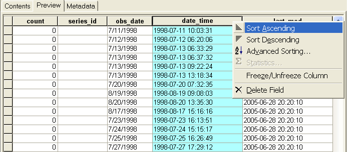
- I want to sort the attribute table by date/time. How can I do it?
-
Since [date_time] field is written in a format appropriate for sorting, the sorting on date/time will work fine even though it's a text type field.
1. Open the attribute table (in ArcMap or ArcCatalog).
2. Select the [date_time] field.
3. Keeping it highlighted, right-click and select 'Sort Ascending/Descending'.
- I don't see the effort shapefile in the zipped file?
- Not all the datasets have effort data. You can make sure if the dataset has effort data in Datasets page ('yes' in 'effort' column) or Dataset Detail page ('Effort' or 'Trackline' row).
- Is a shapefile provided for a species I'm interested in?
- No. Observations of a certain species are dynamically extracted from our huge database. Generating a shapefile for the species will take a long time and affect the web site performance. So we do not currently provide shapefiles for species. However, you can download the observations of a certain species in CSV format, which you can generate shapefiles with ArcCatalog.
- How do I use oceanographic sample data in [oceano] field?
- See "Download sampled values and utilize them" in the Environment page.